
Read the full article on KETV 7
Big changes are on the way in the coming days with high winds, big temperature swings, and snow chances. Omaha’s Weather Leader has deemed Sunday and Monday as impact weather days. Sunday snow, high wind potentialThere’s growing confidence that 50 to 60 mile per hour wind gusts will impact the area during the day Sunday. This will be accompanied with falling temperatures and a chance for wintry mix and snow. As of Friday morning, there is still disagreement among models as to how much snow we could get.One model had most of the accumulating snow north of the metro.Another model has accumulating snow over most of eastern Nebraska and even more in Iowa.Snow timelineRain and wintry mix will arrive overnight Saturday into early Sunday morning, becoming more widespread and transitioning to all snow through the morning. Gusty winds will continue to ramp up into Sunday afternoon, coinciding with periods of snow which could significantly reduce visibility. Snow will taper off Sunday night.As much colder air funnels in, wind chills between -10° and -20° are expected Monday morning.Stay updated on the latest weather forecast by downloading the KETV mobile app.With a combined 50 years covering weather in Nebraska and Iowa, KETV NewsWatch 7 is Omaha’s Weather Leader. Led by Omaha’s Chief Meteorologist Bill Randby, the award-winning team of Sean Everson, Caitlin Harvey and Luke Vickery are focused on alerting you to upcoming severe weather and KETV’s exclusive live radar gives you a 3-minute advantage when storms strike.Make sure you can always see the latest news, weather, sports and more from KETV NewsWatch 7 on Google search.NAVIGATE: Home | Weather | Local News | National | Sports | Newscasts on demand |
Big changes are on the way in the coming days with high winds, big temperature swings, and snow chances. Omaha’s Weather Leader has deemed Sunday and Monday as impact weather days.
Sunday snow, high wind potential
Advertisement
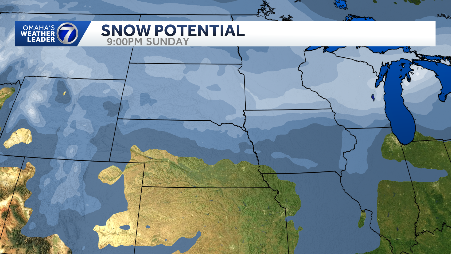
There’s growing confidence that 50 to 60 mile per hour wind gusts will impact the area during the day Sunday. This will be accompanied with falling temperatures and a chance for wintry mix and snow. As of Friday morning, there is still disagreement among models as to how much snow we could get.
One model had most of the accumulating snow north of the metro.

Another model has accumulating snow over most of eastern Nebraska and even more in Iowa.

Snow timeline
Rain and wintry mix will arrive overnight Saturday into early Sunday morning, becoming more widespread and transitioning to all snow through the morning.
Gusty winds will continue to ramp up into Sunday afternoon, coinciding with periods of snow which could significantly reduce visibility.
Snow will taper off Sunday night.
As much colder air funnels in, wind chills between -10° and -20° are expected Monday morning.
Stay updated on the latest weather forecast by downloading the KETV mobile app.
With a combined 50 years covering weather in Nebraska and Iowa, KETV NewsWatch 7 is Omaha’s Weather Leader. Led by Omaha’s Chief Meteorologist Bill Randby, the award-winning team of Sean Everson, Caitlin Harvey and Luke Vickery are focused on alerting you to upcoming severe weather and KETV’s exclusive live radar gives you a 3-minute advantage when storms strike.
Make sure you can always see the latest news, weather, sports and more from KETV NewsWatch 7 on Google search.
NAVIGATE: Home | Weather | Local News | National | Sports | Newscasts on demand |