
Read the full article on KETV 7
Omaha weather: Light snow on St. Patrick’s Day, record warmth to start spring
LEADER, METEOROLOGIST SEAN EVERSON. WITH THE ACCURATE FORECAST, YOU CAN TRUST. ONE MORE DAY OF WINTER WEATHER BEFORE A BIG TIME WARM UP. WATCHING FOR A CHANCE FOR SOME FLURRIES AND LIGHT SNOW HERE ON SAINT PATRICK’S DAY AFTERNOON. AND THEN THE WARM UP IS ON. MORE SPRING LIKE STARTING TOMORROW WITH HIGHS IN THE 60S AND 70S. AND WE START SPRING ON FRIDAY, BUT IT’S GOING TO BE MORE SUMMER-LIKE. RECORD HIGHS POSSIBLE BOTH FRIDAY AND SATURDAY WITH HIGHS IN THE 80S. SO WE’RE REALLY PULLING A 180 AFTER THE START OF THIS WEEK, HOW COLD IT’S BEEN AND IT’S TRYING TO SNOW RIGHT NOW. DRY AIR WINNING OUT SAID THIS MORNING. THAT’S THE LIMITING FACTOR. IF WE CAN OVERCOME THE DRY AIR CLOSER TO THE SURFACE GET A LITTLE BIT OF LIGHT SNOW THOUGH. STARTING TO GET SOME GROUND REPORTS NEAR COLUMBUS, POSSIBLY NORFOLK AS WELL. SEE SUPER DOPPLER SEVEN RADAR. HERE’S THE OMA DOME. THE THE DOME OF DRY AIR. THIS IS WHAT FORMS WHEN THE RADAR BEAMS HITTING THAT SNOW HIGHER UP IN THE ATMOSPHERE. YOU GET ALL THE DRY AIR CLOSER TO THE GROUND, BUT YOU SEE THE DARKER BLUES HERE. SO SOME LIGHT SNOW POSSIBLY COLUMBUS UP TOWARD THE NORFOLK AREA. SO WE’LL SEE IF WE CAN SATURATE ENOUGH TO GET A LITTLE BIT OF LIGHT SNOW HERE OVER THE NEXT COUPLE OF HOURS RIGHT NOW. OTHERWISE IT’S OVERCAST GRAY AS WE LOOK OVER GILES ROAD I-80 RIGHT NOW HERE AT THE NOON HOUR, TEMPERATURES TEENS AND 20S, BUT STILL FEELING LIKE THE SINGLE DIGITS AND TEENS. IT IS A COLD. SAINT PATRICK’S DAY THAT SOUTH WIND RIGHT NOW 10 TO 20MPH COULD SEE SOME GUSTS 20 TO 30MPH. SO THAT’S GOING TO KEEP THAT WIND CHILL DOWN. RELATIVE HUMIDITY GETTING UP IN THE 50S AND 60S AS WE GET INTO THE 70S, THAT’S A BETTER INDICATOR OF THE AIR BEING MORE SATURATED, MORE OF THAT SNOW REACHING THE GROUND. BUT STILL, EVEN WITH THE HUMIDITY CLOSE TO 70 RIGHT NOW IN NORFOLK EXPECT TO SEE SOME LIGHT SNOW FALL. SO 12 HOUR FORECAST. KEEP THE HEAVY JACKET WITH YOU. HEAD HOME FROM WORK, KIDDOS HEADING FROM SCHOOL, AND IF YOU’RE HEADING OUT FOR SAINT PATRICK’S DAY LATER THIS EVENING, IT’S REALLY TWO, THREE, 4:00. OUR BEST OPPORTUNITY TO SEE ANY SNOW AND THEN DRY. STILL JUST CHILLY IN THE EVENING AS THOSE TEMPERATURES REMAIN IN THE MID 30S, BUT NOT A WHOLE LOT OF SNOW. MAYBE UP TO A DUSTING HERE IN THE OMAHA METRO. BETTER CHANCE TO SEE UP TOWARD A HALF AN INCH TOWARD TEKAMAH AND INTO SOUTHWEST IOWA. CARROLL THE ATLANTIC AREA. SO EVEN WITH A LITTLE BIT OF SNOW, THOUGH, WITH THE TIMING COULD STILL SLICK UP OR MAKE FOR SOME DAMP ROADWAYS. AND FOR THE EVENING DRIVE YOU SEE HERE ON STORM PREDICTOR AS WE HEAD TOWARD TWO 3:00, THAT WOULD BE OUR OPPORTUNITY FOR ANY OF THAT LIGHT SNOW. AND THEN BY 5:00, ANY OF THAT SNOW IS OUT OF HERE. AND THEN TEMPERATURES STILL MID 30S THROUGH THE EVENING. WARM FRONT COMES THROUGH OVERNIGHT TOMORROW. WE START OFF IN THE 20S, LOW 30S, AND THEN LOOK AT THE TEMPERATURES SOAR UP AROUND 70 IN THE METRO WELL INTO THE 70S OUT WEST STILL 60S. MOST OF SOUTHWEST IOWA. SO THE WARM UP IS ON 75. BY THURSDAY, 83 WOULD SHATTER RECORD HIGH ON FRIDAY AND NOW SATURDAY RECORD HIGH COULD BE WITHIN REACH. IT LOOKS LIKE OUR WARMEST DAY IN THE MID 80S, SO MORE SUMMER-LIKE FOR THE FIRST SATURDAY OF THE SPRING SEASON. BUT AGAIN TODAY. IMPACT WEATHER WITH THE CHANCE FOR JUST A LITTLE BIT OF LIGHT SNOW HERE T
Advertisement
We’re flipping the switch on winter before the start of the spring. After light snow on St. Patrick’s Day, temperatures will soar toward the end of the week. Omaha’s Weather Leader has deemed Tuesday an impact weather day with a chance for light snow.Snow timelineLight snow is possible Tuesday afternoon mainly between 1 p.m. and 4 p.m. in the Omaha metro. Dry air could be a limiting factor. Any accumulation would be light in the metro, just a trace to a dusting. Better chance to see up to 0.5 inches will be north and east of the Omaha metro.Watch out for possible wet or slick conditions for the evening commute with temperatures climbing into the mid 30s.Big warm up aheadA warm front will pass through Tuesday night and temperatures will trend much warmer for the rest of the week. Spring arrives Friday and temperatures will be summer-like with highs in the 80s. Multiple record highs are possible. Omaha’s record high for Friday, March 20th is 78 degrees set back in 1934. Lincoln’s record high is 80 degrees set in 2022. Norfolks record high is 81 degrees set back in 1934.Stay updated on the latest weather forecast by downloading the KETV mobile app.With a combined 50 years covering weather in Nebraska and Iowa, KETV NewsWatch 7 is Omaha’s Weather Leader. Led by Omaha’s Chief Meteorologist Bill Randby, the award-winning team of Sean Everson, Caitlin Harvey and Luke Vickery are focused on alerting you to upcoming severe weather and KETV’s exclusive live radar gives you a 3-minute advantage when storms strike.Make sure you can always see the latest news, weather, sports and more from KETV NewsWatch 7 on Google search.NAVIGATE: Home | Weather | Local News | National | Sports | Newscasts on demand |
We’re flipping the switch on winter before the start of the spring. After light snow on St. Patrick’s Day, temperatures will soar toward the end of the week. Omaha’s Weather Leader has deemed Tuesday an impact weather day with a chance for light snow.
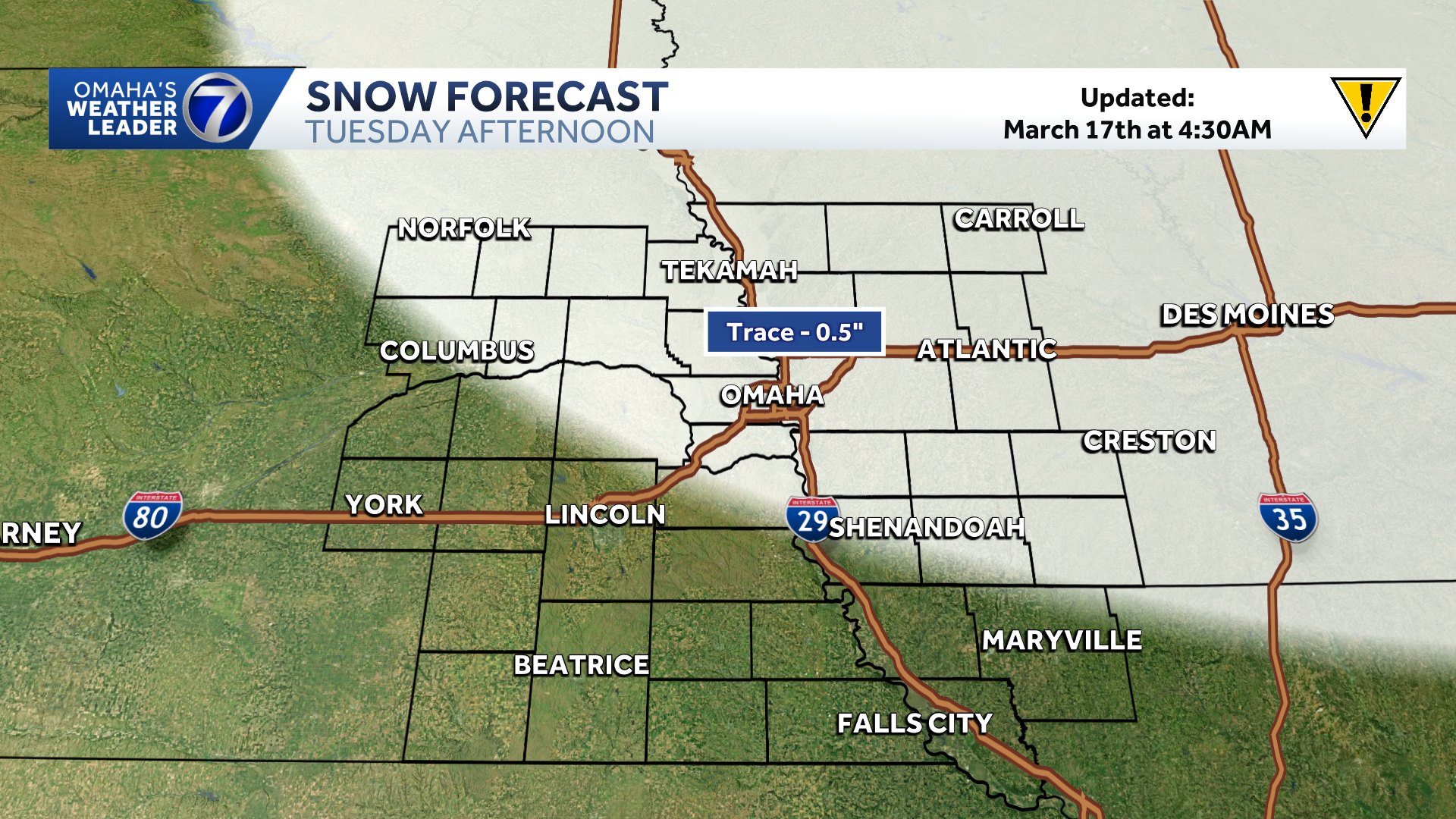
Snow timeline
Advertisement
Light snow is possible Tuesday afternoon mainly between 1 p.m. and 4 p.m. in the Omaha metro. Dry air could be a limiting factor. Any accumulation would be light in the metro, just a trace to a dusting. Better chance to see up to 0.5 inches will be north and east of the Omaha metro.

Watch out for possible wet or slick conditions for the evening commute with temperatures climbing into the mid 30s.
Big warm up ahead
A warm front will pass through Tuesday night and temperatures will trend much warmer for the rest of the week. Spring arrives Friday and temperatures will be summer-like with highs in the 80s. Multiple record highs are possible. Omaha’s record high for Friday, March 20th is 78 degrees set back in 1934. Lincoln’s record high is 80 degrees set in 2022. Norfolks record high is 81 degrees set back in 1934.

Stay updated on the latest weather forecast by downloading the KETV mobile app.
With a combined 50 years covering weather in Nebraska and Iowa, KETV NewsWatch 7 is Omaha’s Weather Leader. Led by Omaha’s Chief Meteorologist Bill Randby, the award-winning team of Sean Everson, Caitlin Harvey and Luke Vickery are focused on alerting you to upcoming severe weather and KETV’s exclusive live radar gives you a 3-minute advantage when storms strike.
Make sure you can always see the latest news, weather, sports and more from KETV NewsWatch 7 on Google search.
NAVIGATE: Home | Weather | Local News | National | Sports | Newscasts on demand |