
Read the full article on KETV 7
Winter storm to impact Omaha area Thursday
THINGS, HAS A HUGE IMPACT ON AN AREA LIKE THE OMAHA METRO. SO WE ANTICIPATED THIS HEAVY SNOW COMING IN MID-AFTERNOON. THAT’S WHAT WE HAVE HERE THIS EVENING. RANDBY FACTOR I DEBATED THIS TO BE A ONE. I MEAN, I’D PREFER YOU DIDN’T HAVE TO GO OUTSIDE. A HORRIBLE DRIVING CONDITIONS WITH TIME AS WE GO THROUGH THIS EVENING HERE, THE WINTER STORM WARNING HAS BEEN EXPANDED TO NOW INCLUDE CASS COUNTY, NEBRASKA. MEALS. COUNTY OF WESTERN IOWA, AND ALSO A COUPLE MORE COUNTIES IN THE WINTER WEATHER ADVISORY. THAT’S BECAUSE THE SNOW BAND, WHICH HAS BEEN SO HEAVY ALREADY PRODUCING 2 TO 3IN OF SNOW IN PARTS OF CASS COUNTY, IS UP INTO THE OMAHA METRO NOW, BUT IT’S STILL SNOWING IN THOSE AREAS, SO TOUGH CONDITIONS THERE, TOUGH CONDITIONS IN LINCOLN, SAUNDERS COUNTY, AND THIS HEAVY SNOW IS EDGING NORTHWARD. WE’LL GET INTO FREMONT, WE’LL GET INTO BLAIR. AND SO I DID ADJUST THIS MAP TO A LITTLE WIDER 3 TO 6 SWATH. SO FROM WEEPING WATER AND PLATTSMOUTH UP TO THE SOUTH PART OF THE OMAHA METRO, AND THAT 6 TO 8 INCH BAND MIGHT INCLUDE BENNINGTON MIGHT INCLUDE FORT CALHOUN AND MAYBE OUT HERE INTO FREMONT. HERE’S OUR COMPUTER MODEL SHOWS YOU THE INDICATION. THE HEAVIEST SNOW RIGHT OVER THE OMAHA METRO. FIVE, SIX, SEVEN TRIES TO PUSH SOME OF THAT FARTHER NORTH, BUT THERE’S THIS COLD, DRY AIR, THAT NORTH WIND, WHICH SORT OF PUTS AN EDGE TO HOW FAR NORTH THE SNOW CAN GET. SO IT JUST SORT OF STAYS IN PLACE JUST NEAR AND NORTH OF THE OMAHA METRO ENDING. WE GET BEYOND MIDNIGHT. THAT COMPUTER MODEL SUGGESTS THIS AMOUNT OF SNOW SLIGHTLY MORE IN OMAHA AND FREMONT. AND YOU KNOW, PLATTSMOUTH ALREADY HAD ABOUT THREE INCHES OF SNOW, SO THEY’LL PROBABLY WIND UP WITH A BIT MORE THAN THAT. SO THE THE IDEA IS THAT THE VERY HEAVIEST SNOW IS PROBABLY SETTLING RIGHT ABOUT OVER DOWNTOWN, OR JUST BARELY TO THE NORTH OF THE METRO AND THEN UP ALONG I-80 ACROSS WESTERN IOWA. THE EUROPEAN COMPUTER MODEL HAS IT A BIT FARTHER NORTH, BUT THAT WAS A RUN FROM EARLIER TODAY. THE TREND IS THAT THE HEAVIEST SNOW BAND IS CLOSEST NOW TO THE OMAHA METRO. THAT’S THE INTERSECTION OF HIGHWAY 370 AND 72ND. FROM OUR CAMERA AT THE COBALT CREDIT UNION, YOU CAN SEE HOW QUICKLY IT’S BEGUN ACCUMULATING ON THE ROADWAYS 27 DEGREES FOR THE TEMPERATURE, 25 IN FREMONT 28 TEKAMAH BILL TALKED ABOUT THIS YESTERDAY. WAIT FOR IT. A TEMPERATURE CHANGE OF NEARLY 40 DEGREES COLDER IN LINCOLN THAN THIS TIME YESTERDAY. 33 DEGREES COLDER IN THE OMAHA METRO, AND THE FEELS LIKE IS NOW SINGLE DIGITS IN LINCOLN AND LOW TEENS HERE IN OMAHA. WHAT AN AMAZING TURN. AND WITH THAT NORTH WIND THE SNOW JUST PROBABLY GOING TO BE LOCKED IN PLACE ALONG THIS LINE. IF YOU’VE GOT TO GO OUT THIS EVENING, PLAN ON EXTRA TIME GETTING WHERE YOU’RE GOING. WINTER STORM WARNING ALL NIGHT UNTIL 6 A.M. TOMORROW, YOU KNOW, THREE TO MAYBE AS MUCH AS SEVEN INCHES OF SNOW ACROSS THE OMAHA METRO. LIGHTEST AMOUNTS SOUTH METRO. HEAVIEST AMOUNTS NORTH METRO 14 FOR THE LOW TEMPERATURE, THE SNOW. TOMORROW WILL PROBABLY STILL HAVE SOME CLEANUP WORK TO DO. MAYBE SOME ICY SPOTS ON SOME OF THE ROADWAYS, MAYBE EVEN DIFFICULT TRAVEL IN SOME OUTLYING AREAS BECAUSE THERE’S GOING TO BE SOME WIND BLOWING WITH THIS BLOWING THE SNOW AROUND, MAKING IT DIFFICULT TO CLEAN UP. AND THEN YOU LOOK AT THE SEVEN DAY. WELL, THIS IS IT. AS FAR AS SNOWFALL, IT DOES LOOK LIKE WE’LL BE QUITE COLD THROUGH THE WEEKEND. AND IF WE HAVE LIGHT ENOUGH WINDS ON MONDAY MORNING WITH THE SNOW THAT WE’RE GOING TO HAVE ON THE GROUND, IT COULD GO BELOW ZERO. WE’RE THINKING IT’S STILL GOING TO WARM UP SOME NEXT WEEK, ALTHOUGH WE’LL HAVE TO SEE HOW MUCH SNOW WE MELT BY TUESDAY OR WEDNESDAY OR THURSDAY. YEAH, TODAY. THIS IS THE KIND OF WEATHER YOU DON’T WANT TO BE OUT. IF
Advertisement
After record warmth to start the week, big changes are coming. Omaha’s Weather Leader has deemed Thursday a severe winter weather day with a winter storm on the way.Thursday snow potentialA winter storm warning has been issued by the National Weather Service for parts of eastern Nebraska and southwest Iowa, including the Omaha metro, from noon Thursday through 6 a.m. on Friday. As of Thursday morning, the Omaha metro and most areas along and north of Interstate 80 could see 3 to 6 inches of snow. It’s possible there could be a a narrower band of 6 to 8 inches on the north side of the metro. Expect a sharp drop off to the south of the metro outside of the forecasted heavier snow band.Snow TimelineMost of the snow would likely fall in the afternoon and evening Thursday, mainly after 1 p.m. in the metro, which would lead to a very impactful evening drive. Most of the snow should exit the viewing area after midnight.Stay updated on the latest weather forecast by downloading the KETV mobile app.With a combined 50 years covering weather in Nebraska and Iowa, KETV NewsWatch 7 is Omaha’s Weather Leader. Led by Omaha’s Chief Meteorologist Bill Randby, the award-winning team of Sean Everson, Caitlin Harvey and Luke Vickery are focused on alerting you to upcoming severe weather and KETV’s exclusive live radar gives you a 3-minute advantage when storms strike.Make sure you can always see the latest news, weather, sports and more from KETV NewsWatch 7 on Google search.NAVIGATE: Home | Weather | Local News | National | Sports | Newscasts on demand |
After record warmth to start the week, big changes are coming. Omaha’s Weather Leader has deemed Thursday a severe winter weather day with a winter storm on the way.
Thursday snow potential
Advertisement
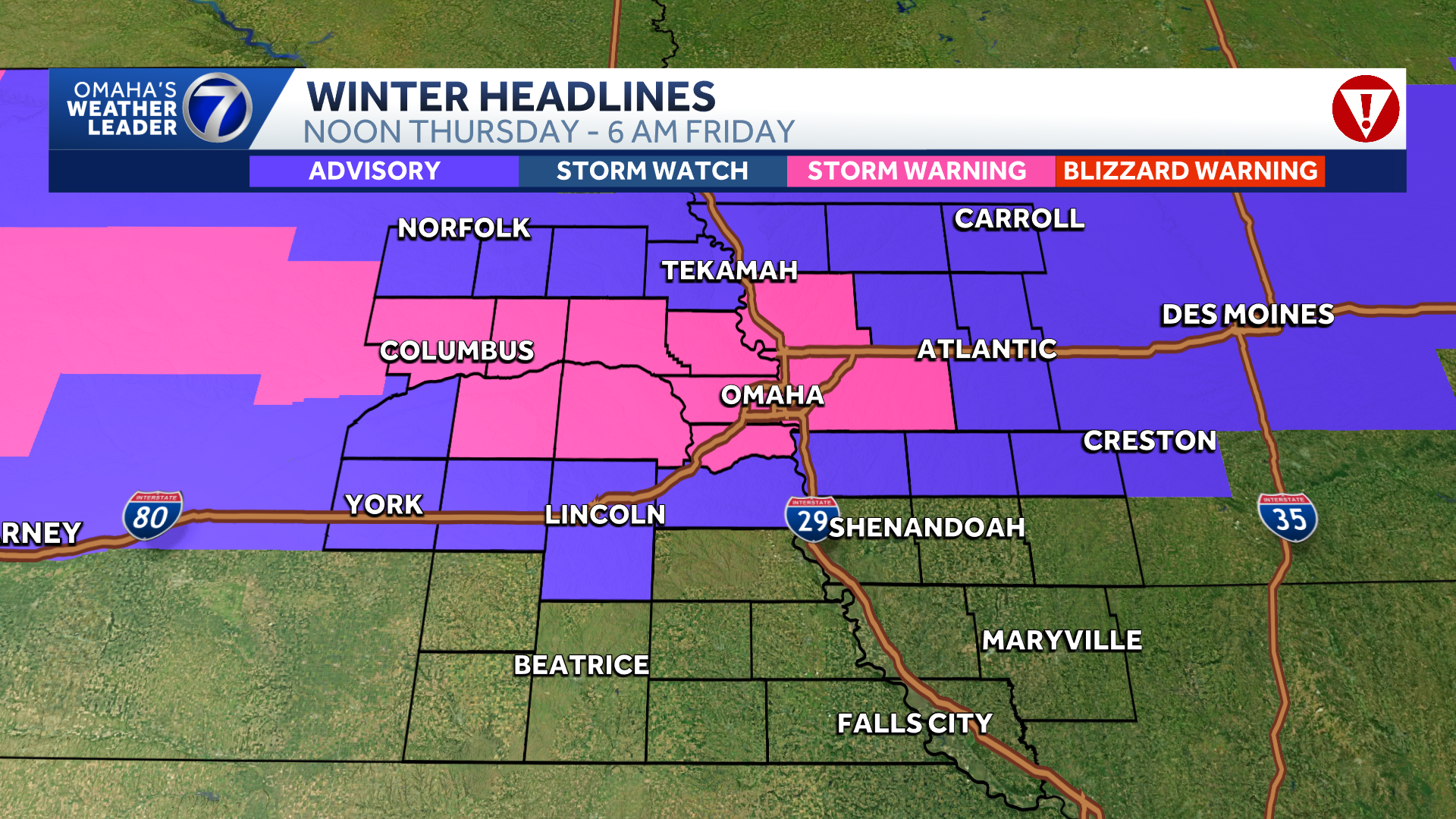
A winter storm warning has been issued by the National Weather Service for parts of eastern Nebraska and southwest Iowa, including the Omaha metro, from noon Thursday through 6 a.m. on Friday.

As of Thursday morning, the Omaha metro and most areas along and north of Interstate 80 could see 3 to 6 inches of snow. It’s possible there could be a a narrower band of 6 to 8 inches on the north side of the metro. Expect a sharp drop off to the south of the metro outside of the forecasted heavier snow band.

Snow Timeline
Most of the snow would likely fall in the afternoon and evening Thursday, mainly after 1 p.m. in the metro, which would lead to a very impactful evening drive. Most of the snow should exit the viewing area after midnight.
Stay updated on the latest weather forecast by downloading the KETV mobile app.
With a combined 50 years covering weather in Nebraska and Iowa, KETV NewsWatch 7 is Omaha’s Weather Leader. Led by Omaha’s Chief Meteorologist Bill Randby, the award-winning team of Sean Everson, Caitlin Harvey and Luke Vickery are focused on alerting you to upcoming severe weather and KETV’s exclusive live radar gives you a 3-minute advantage when storms strike.
Make sure you can always see the latest news, weather, sports and more from KETV NewsWatch 7 on Google search.
NAVIGATE: Home | Weather | Local News | National | Sports | Newscasts on demand |