
Read the full article on KETV 7

Severe weather day Thursday: winter storm warning for Omaha area
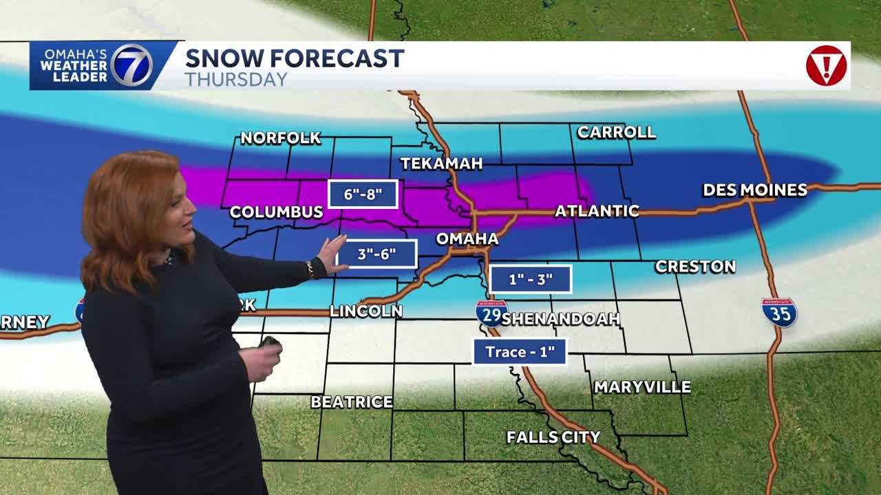
FROM THERE TO MAYBE 4 OR 5 HOURS FROM NOW. THAT EVENING DRIVE, IT IS GOING TO BE A MESS. AND IT’S NOT IF IT’S IT’S WHEN. MOST DEFINITELY RIGHT NOW, STILL DRY ACROSS THE OMAHA METRO. THAT SNOW, THAT MOISTURE COMING IN FROM THE SOUTH, TRYING TO EAT THROUGH THIS DRY AIR, BEGINNING NOW WITH A LIVE LOOK ACROSS OUR METRO AREA WITH OUR EXCLUSIVE SKY CAM NETWORK FROM DOWNTOWN OMAHA TO COUNCIL BLUFFS, LA VISTA OUT TO OUR NEW CAMERA OUT AT LAKE WAHOO. WE ARE STILL SEEING THOSE DRY, PRETTY QUIET CONDITIONS, BUT AS OF 15 MINUTES AGO, OUR WINTER STORM WARNING IN EFFECT AND WILL REMAIN SO UNTIL 6:00 TOMORROW MORNING. CURRENT TEMPERATURES IN THE METRO INTO THE UPPER 20S AND LOW 30S 32 NOW COUNCIL BLUFFS, 31. OMAHA 26. FREMONT 27. BLAIR TEKAMAH. COLDER 19. NORFOLK 37. CRESTON. AND OUR FEELS LIKE TEMPERATURES IS DECEIVING IN THE TEENS MAINLY, AND THEN SINGLE DIGITS FURTHER WEST. FEELING LIKE ONE SINGLE DEGREE NOW IN NORFOLK WITH THOSE GUSTS UP TO ABOUT 45 MILES AN HOUR SUSTAINED WINDS. THE ONES THAT DON’T LET UP. UP TO ABOUT 20 TO 25 MILES AN HOUR. SO AGAIN, WINDY. AND AS THAT SNOW DOES START TO FALL, THESE STRONG WIND GUSTS COULD BLOW SOME OF THAT SNOW AROUND AS IT’S FALLING, CREATING VERY POOR VISIBILITY. CHECKING IN WITH LIVE DEUEL PULSE SUPER DOPPLER, OUR THREE-MINUTE ADVANTAGE. STILL PUTTING THAT SNOW FURTHER SOUTH. WE ARE GETTING A LITTLE BIT OF SNOW JUST OUT OF OUR VIEWING AREA TO THE NORTH, BUT TAKING A CLOSER LOOK, LOOK ON SOUTH AND THROUGH PAWNEE CITY AUBURN EVEN UP INTO BEDFORD AND THE CRESTON AREAS. STARTING TO SEE THAT POTENTIAL FOR SOME LIGHT SNOW AS IT DOES EAT THROUGH THE DRY AIR. NOW A FEW OF US TEMPERATURES JUST ABOVE FREEZING WITH SNOWFALL RATES ANTICIPATED UP TO ONE INCH AN HOUR, THAT COULD DRAG THOSE LEVELS DOWN MEAN YOU COULD SEE SOME WET SNOW, EVEN JUST ABOVE FREEZING HERE AT THE GROUND LEVEL. NOW, OUR WINTER STORM WARNING, IN EFFECT, HAS NOW BEEN EXTENDED ON FROM THE OMAHA. OMAHA METRO INTO THE DES MOINES METRO UNTIL 6 A.M. FRIDAY, EXPECTING SNOWFALL AMOUNTS HIGHER IN THE WARNED AREAS. STILL EXPECTING SOME SNOW, WHICH WILL IMPACT THAT EVENING COMMUTE FOR OUR ADVISORY AREAS, WHICH DOES INCLUDE LINCOLN UP THROUGH NORFOLK BUT EXPECTING THAT SHARP CUTOFF OF SNOW TO BRING EVEN UP TO 6 TO 8IN HERE IN THE PURPLE. THIS JUST NORTH OF THE OMAHA AREA, BUT OMAHA STILL ANTICIPATING HERE IN THE DARK BLUE, 3 TO 6IN. THIS INCLUDES NOW OVER INTO DES MOINES. MOST OF THE AREA THOUGH GOING TO GET THAT ACCUMULATION. AND THEN JUST SOUTH OF I-80 SHARP CUTOFF 1 TO 3IN TRACE AMOUNTS FURTHER SOUTH HERE THIS AFTERNOON 33 DEGREES. WINDY. THOSE TEMPERATURES STARTING TO DROP OFF INTO THE WEST. 31 TODAY LINCOLN. AND TONIGHT WE KEEP OUR SEVERE WEATHER WITH US WITH SNOW ENDING BY 1 A.M., TEMPERATURES DOWN TO ABOUT 15 DEGREES, AND YOUR SEVEN DAY FORECAST SEVERE WEATHER DAY TODAY. EXPECTING THAT HEAVY SNOW, GUSTY WINDS 33. YOUR HIGH TOMORROW. IMPACT WEATHER THAT SNOW AGAIN MOVING OUT BY 1 A.M. BUT WE’RE EXPECTING SLICK ROAD CONDITIONS HIGH OF 29. KEEPING IT COLD RIGHT AROUND FREEZING THROUGHOUT THE WEEKEND AND TO START NEXT WEEK
Advertisement
A winter storm warning remains in effect for eastern Nebraska and western Iowa through early Friday. Accumulating and blowing snow is expected with difficult travel possible.With a combined 50 years covering weather in Nebraska and Iowa, KETV NewsWatch 7 is Omaha’s Weather Leader. Led by Omaha’s Chief Meteorologist Bill Randby, the award-winning team of Sean Everson, Caitlin Harvey and Luke Vickery are focused on alerting you to upcoming severe weather and KETV’s exclusive live radar gives you a 3-minute advantage when storms strike.
A winter storm warning remains in effect for eastern Nebraska and western Iowa through early Friday. Accumulating and blowing snow is expected with difficult travel possible.
With a combined 50 years covering weather in Nebraska and Iowa, KETV NewsWatch 7 is Omaha’s Weather Leader. Led by Omaha’s Chief Meteorologist Bill Randby, the award-winning team of Sean Everson, Caitlin Harvey and Luke Vickery are focused on alerting you to upcoming severe weather and KETV’s exclusive live radar gives you a 3-minute advantage when storms strike.
Advertisement