
Read the full article on KETV 7
Strong storms possible Friday afternoon in Nebraska, Iowa
Strong thunderstorms possible south of I-80
THIS IS A SEVERE WEATHER UPDATE FROM OMAHA’S WEATHER LEADER. GOOD AFTERNOON FOLKS. CHIEF METEOROLOGIST BILL RANDBY HERE. JUST WANTED TO UPDATE YOU ON THE WEATHER SITUATION FOR THE AFTERNOON. THERE’S BEEN A LOT OF TALK AND A LOT OF MAYBE FEAR MONGERING MONGERING BY SOME OF THE TV STATIONS IN TOWN. WE’VE GOT NOTHING GOING ON THROUGH THE OMAHA METRO, BUT A HUGE COLD FRONT HAS PUSHED THROUGH. ABOUT AN HOUR AGO. THERE WAS A LITTLE SHOWER THAT STARTED POPPING UP AROUND LINCOLN, AND I’M SURE THERE WAS A LOT OF THOUGHT, WELL, THIS IS GOING TO BE IT. BUT THE FRONT MOVED SOUTH AND THAT MOVED INTO THE COLDER AIR, AND NOW WE’VE GOT NOTHING GOING ON. A LITTLE LATER THIS EVENING, I DO THINK THE ATMOSPHERE IS MORE CONDUCIVE FOR STRONG OR SEVERE STORMS DOWN HERE TOWARD NEBRASKA CITY. AUBURN TECUMSEH, ATCHISON COUNTY, MISSOURI. BUT HERE IN THE OMAHA METRO, IT’S ALREADY COLD AND UNLIKELY THAT WE’RE GOING TO SEE REALLY SUPER STRONG THUNDERSTORMS. THERE’S NOTHING YET FROM THE STORM PREDICTION CENTER. I THINK EVENTUALLY WE’RE GOING TO GET A TORNADO WATCH OR A SEVERE WEATHER WATCH FOR AREAS NEAR AND SOUTHEAST OF THE OMAHA METRO. AND IF SOMETHING DOES GET GOING QUICKLY HERE, IT’S POSSIBLE WE COULD STILL SEE A STORM PRODUCE HAIL UP INTO THE METRO. BUT THIS IS THAT FRONT ALREADY PUSHING SOUTH OF THE OMAHA METRO AND STILL NOTHING GETTING GOING. SO STORMS KIND OF HAVE TO DEVELOP HERE IN NORTHEAST KANSAS AND MOVE NORTHEASTWARD TO BE ACTIVE STORMS FOR SOUTHEAST NEBRASKA. LOOK AT THE TEMPERATURES. I MEAN, BACK AT 1:00, IT WAS 73 IN OMAHA. IT’S NOW 48. IT’S 50 IN LINCOLN, 38 IN FREMONT. AND THAT COLD AIR IS PUSHING SOUTH. ONCE THE COLD AIR MOVES THROUGH. THAT ENDS YOUR CHANCE OF A TORNADO IN THE TORNADO. RISK IS STILL PRETTY LOW. WE’VE BEEN SAYING FOR A COUPLE OF DAYS THAT IF THAT WAS GOING TO BE SOMETHING THAT WOULD OCCUR, IT WOULD BE SOUTH AND EAST OF THE OMAHA METRO. AND WHILE IT’S STILL WARM DOWN THERE, IT’S STILL EVEN THERE. IT DOESN’T LOOK PERFECT FOR DEVELOPMENT OF TORNADOES. SO HOURLY PLANNER I DON’T THINK WE’LL HAVE ANYTHING TOO BAD IN THE METRO AT 4:00. OUR WINDOW FOR SEVERE STORMS IN OMAHA IS KIND OF THAT 5:00 6:00 TIME FRAME. AND LATER ON, IT’S JUST THAT IT’S SO COLD ALREADY, IT WILL BE HARD FOR US TO GET ANY KIND OF WIND OR TORNADO UP TO THE OMAHA METRO. IF YOU’RE SOUTHEAST OF OMAHA, THOUGH, YOU REALLY STILL WANT TO PAY ATTENTION. I EXPECT A SEVERE WEATHER WATCH TO COME OUT, AND OF COURSE WE’LL BE FOLLOWING THE ACTIVE WEATHER AS THE TEMPERATURES GET COLDER THROUGHOUT THE VIEWING AREA TONIGHT. KEEP IT HERE
Advertisement
Strong storms possible Friday afternoon in Nebraska, Iowa
Strong thunderstorms possible south of I-80

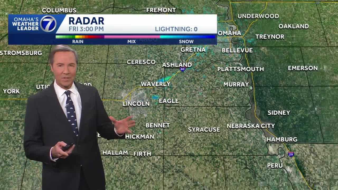
Another round of storms is possible Friday afternoon and evening as a cold front moves through the area. Severe thunderstorms will be possible mostly south of interstate 80. Any storms that form near Omaha will primarily pose a hail threat. There is a chance of thunderstorms posing an all hazards risk including isolated tornadoes further south. This would be in areas from Beatrice to Nebraska City to Shenandoah and southward. With a combined 50 years covering weather in Nebraska and Iowa, KETV NewsWatch 7 is Omaha’s Weather Leader. Led by Omaha’s Chief Meteorologist Bill Randby, the award-winning team of Sean Everson, Caitlin Harvey and Luke Vickery are focused on alerting you to upcoming severe weather and KETV’s exclusive live radar gives you a 3-minute advantage when storms strike.
Another round of storms is possible Friday afternoon and evening as a cold front moves through the area. Severe thunderstorms will be possible mostly south of interstate 80.
Advertisement
Any storms that form near Omaha will primarily pose a hail threat. There is a chance of thunderstorms posing an all hazards risk including isolated tornadoes further south. This would be in areas from Beatrice to Nebraska City to Shenandoah and southward.
With a combined 50 years covering weather in Nebraska and Iowa, KETV NewsWatch 7 is Omaha’s Weather Leader. Led by Omaha’s Chief Meteorologist Bill Randby, the award-winning team of Sean Everson, Caitlin Harvey and Luke Vickery are focused on alerting you to upcoming severe weather and KETV’s exclusive live radar gives you a 3-minute advantage when storms strike.