
Read the full article on KETV 7
Omaha weather: Up and down temperatures ahead, Wednesday rain, snow chance
911. BILL BACK WITH US NOW AND GRAY. AND IS THERE A TIMING ON THIS RAIN? YEAH, JUST A FEW LITTLE LIGHT RAIN AND SNOW SHOWERS HERE THROUGH THE EVENING. WE MIGHT GET SOME SPRINKLES, YOU KNOW, JUST HERE OR THERE. PROBABLY NOT ENOUGH TO CAUSE ANY HUGE ISSUES. BUT WE WANT FOLKS TO BE AWARE. AND THIS EVENING, IF YOU’VE GOT SOME PLANS TO BE OUTSIDE, BECAUSE I DON’T THINK IT WILL BE ENOUGH TO REALLY STOP ANY OUTDOOR ACTIVITIES. BE FACTOR FIVE TOLERABLE. CERTAINLY NOT GREAT, BUT WE HAVE GREATER DAYS AHEAD. HERE’S LIVE DEUEL POLK. JULIE WAS ASKING TIMING. WELL, IF YOU’RE IN GRETNA, THERE’S A LITTLE SPRINKLE JUST WEST OF YOU HERE IN THESE LIGHT SHOWERS. STANTON COUNTY AND DOWN INTO PLATTE COUNTY. THEY’RE SORT OF HEADED EASTWARD. THERE’S OUR COMPUTER MODEL A LITTLE MORE IN THE WAY OF LIGHT PRECIPITATION INDICATED HERE. 7:00 ISH. THEN A FEW MORE SPRINKLES. AND IF THERE’S GOING TO BE ANY LITTLE LIGHT COATING OF SNOW, IT’S GOING TO BE DENNISON, CARROLL AND AUDUBON. AND THERE THE TEMPERATURES WILL BE COOLER. WE SHOULD BE JUST ABOVE FREEZING HERE IN THE METRO, BUT BEYOND MIDNIGHT, ALL THE CLOUDS PRECIPITATION WILL CLEAR OUT AND THEN THE TEMPERATURES DROP BELOW FREEZING. SO I DON’T THINK IT’S AN ISSUE THIS EVENING. THAT’S THE EUROPEAN COMPUTER MODEL HAS THAT VERY LIGHT PRECIPITATION TONIGHT ACROSS IOWA. BUT WE’RE ALSO WATCHING THIS. MAYBE SUNDAY A CHANCE WE SEE A LITTLE MORE SNOW ACROSS EASTERN NEBRASKA, WESTERN IOWA. NOT A BIG SNOWSTORM. NOT LIKE LAST WEEK, BUT MAYBE ENOUGH TO INCONVENIENCE YOU. 37 AND 30. THAT’S NOT MUCH OF A CHANGE FOR THE TEMPERATURES. AND OFFICIALLY NO MOISTURE YET, AND WE’RE IN DECENT SHAPE FOR THE MONTH AND ALSO FOR THE YEAR WITH THE SNOW FROM LAST WEEK. THERE’S THE CLOUD COVER FROM OUR CAMERA AT H AND H KIA. THAT’S LOOKING BACK TO THE NORTHEAST. IT’S 37. THE WIND IS LIGHT OUT OF THE EAST, AND THAT’S KEPT US COOL. AND OMAHA AND BLAIR. COUNCIL BLUFFS FARTHER SOUTH, THERE’S BEEN SOME SUN. THERE ISN’T ANY SNOW ON THE GROUND, AND YOU’VE GOT 56 IN MARYVILLE, FALLS CITY AND 58 HERE IN BEATRICE. BUT WITH THIS EAST BREEZE AND CLOUDS AND SNOW COVER NEAR AND NORTH OF OMAHA, WE HAVEN’T WARMED. WE’RE NOT GOING TO WARM THIS EVENING OR TONIGHT. HERE’S THE LIGHT PRECIPITATION THERE. YOU CAN SEE IT COMING SOUTHEASTWARD. PROBABLY LOOKS WORSE ON THIS THAN IT REALLY IS. IT’S JUST GOING TO BE VERY LIGHT IF WE GET ANYTHING AT ALL. A LITTLE DISTURBANCE SLIDING FROM SOUTH DAKOTA INTO NEBRASKA. ONCE THAT ZIPS BY, THEN IT WILL BE GONE. AND THEN WE LOOK AT MUCH MILDER PACIFIC AIR MOVING IN STARTING TOMORROW AND GOING INTO FRIDAY. TONIGHT’S LOW 27. WE’VE GOT IMPACT WEATHER JUST FOR THE FEW RAIN OR SNOW SHOWERS THAT WILL BE AROUND THIS EVENING. TOMORROW. HARD TO BELIEVE, BUT WE’RE SOARING INTO THE UPPER 50S IN THE AFTERNOON WITH SUNSHINE MIDDAY IN THE AFTERNOON AND THEN MID AND UPPER 60S FOR FRIDAY, BUT THEN A COLD FRONT GETS DOWN IN HERE ON SATURDAY. NORTH WINDS, DROPS, TEMPERATURES A LOT AND THEN THE SNOW CHANCE THERE ON SUNDAY. SO IMPACT WEATHER FOR SUNDAY IF YOU’VE GOT TRAVEL PLANS JUST GOING TO BE OUT AND ABOUT. MAYBE ENOUGH TO CAUSE SOME ISSUES ON SUNDAY AND THEN SOME RAIN, MAYBE THE MIDDLE OF NEXT WEEK, JUST PAY SOME EXTRA ATTENTION ON SUNDAY, RIGHT? ABSOLUTELY. THANKS, BILL. WELL, WITH LAST WEEK’S SNOWFALL AND A CHANCE FOR RAIN ON TODAY’S IMPACT WEATHER DAY, HOW’S THIS MONTH’S SNOW AND RAIN TO
Advertisement
After a stretch of cold temperatures, a warm up is on the way, but there a chance some could see rain and snow before the end of the week. Omaha’s Weather Leader has deemed Wednesday an impact weather day with a chance for rain and snow for parts of the KETV viewing area.Warming temperaturesAfter highs remained in the 20s last Friday through this Monday, temperatures will climb above average for the rest of the week. Wednesday rain and snow potentialA quick-moving system will bring precipitation chances back into the forecast Wednesday afternoon into Wednesday night. As of Wednesday morning, chances for scattered rain showers will go up Wednesday afternoon after 4 p.m. in the Omaha metro with a better chance of a wintry mix or snow northeast. Most of the precipitation will likely stay rain into the night in Omaha though a brief mix can’t be ruled out. Better chance for light snow accumulation from a trace to 1 inch will remain north and east of the metro.Stay updated on the latest weather forecast by downloading the KETV mobile app.With a combined 50 years covering weather in Nebraska and Iowa, KETV NewsWatch 7 is Omaha’s Weather Leader. Led by Omaha’s Chief Meteorologist Bill Randby, the award-winning team of Sean Everson, Caitlin Harvey and Luke Vickery are focused on alerting you to upcoming severe weather and KETV’s exclusive live radar gives you a 3-minute advantage when storms strike.Make sure you can always see the latest news, weather, sports and more from KETV NewsWatch 7 on Google search.NAVIGATE: Home | Weather | Local News | National | Sports | Newscasts on demand |
After a stretch of cold temperatures, a warm up is on the way, but there a chance some could see rain and snow before the end of the week. Omaha’s Weather Leader has deemed Wednesday an impact weather day with a chance for rain and snow for parts of the KETV viewing area.
Warming temperatures
Advertisement
After highs remained in the 20s last Friday through this Monday, temperatures will climb above average for the rest of the week.

Wednesday rain and snow potential
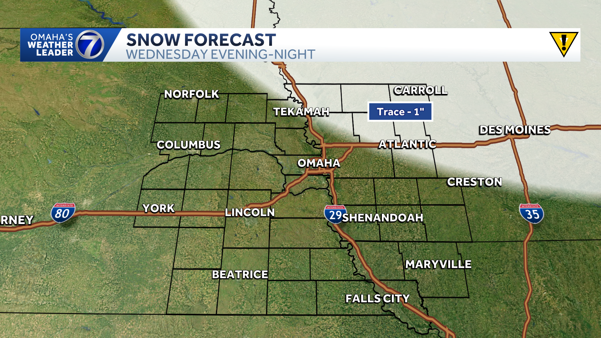
A quick-moving system will bring precipitation chances back into the forecast Wednesday afternoon into Wednesday night. As of Wednesday morning, chances for scattered rain showers will go up Wednesday afternoon after 4 p.m. in the Omaha metro with a better chance of a wintry mix or snow northeast. Most of the precipitation will likely stay rain into the night in Omaha though a brief mix can’t be ruled out. Better chance for light snow accumulation from a trace to 1 inch will remain north and east of the metro.

Stay updated on the latest weather forecast by downloading the KETV mobile app.
With a combined 50 years covering weather in Nebraska and Iowa, KETV NewsWatch 7 is Omaha’s Weather Leader. Led by Omaha’s Chief Meteorologist Bill Randby, the award-winning team of Sean Everson, Caitlin Harvey and Luke Vickery are focused on alerting you to upcoming severe weather and KETV’s exclusive live radar gives you a 3-minute advantage when storms strike.
Make sure you can always see the latest news, weather, sports and more from KETV NewsWatch 7 on Google search.
NAVIGATE: Home | Weather | Local News | National | Sports | Newscasts on demand |