
Read the full article on KETV 7

Windy tonight and weekend snow chance Omaha
Windy tonight and weekend snow chance Omaha
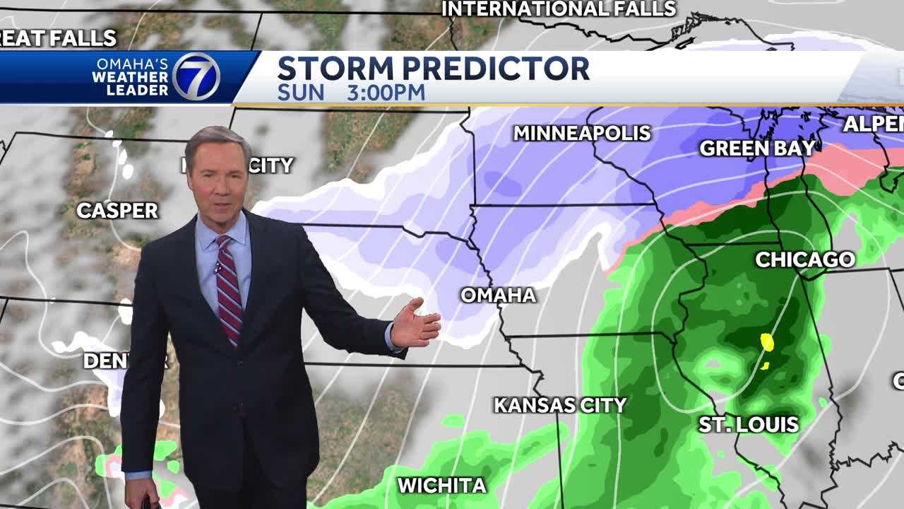
SHAKE. NOTHING ON THE TWO AND A HALF, THOUGH. YEAH, YEAH. TECHNICALLY AN AFTERSHOCK, I GUESS. YOU KNOW, WE USED TO SAY, WELL, WE GET TORNADOES. SURE, BUT WE DON’T GET EARTHQUAKES AROUND HERE. NOW WE DO. AGAIN THIS EVENING. THE WIND HAS BEEN A BIG STORY AND LIKELY TO CONTINUE TO BE A BIG STORY. RANDBY FACTOR TIME. I SAY IT IS A FOUR. UNPLEASANT FOR BEING AND WORKING OUTSIDE BECAUSE OF THAT STRONG WIND. A RED FLAG WARNING AREA WIDE THAT GOES THROUGH 9:00 AND THEN A WIND ADVISORY. AND ALSO A HIGH WIND WARNING OVERNIGHT TONIGHT WHERE THE WINDS ARE GOING TO PICK UP FROM THE NORTHWEST AS A COLD FRONT MOVES THROUGH THE AREA. THEN THERE’S THE WEEKEND SYSTEM WE’RE TRACKING. THIS IS OUR COMPUTER MODEL FORECAST FOR THE EUROPEAN COMPUTER MODEL FOR 4 A.M. SUNDAY. SOME RAIN IN THE AREA. SNOW OFF TO THE NORTH OF US AND THE LOW IS FORECAST TO TRACK EASTWARD. AND THEN ON THE BACK SIDE, THE QUESTION IS HOW MUCH SNOW WILL WRAP IN BEHIND IT. THAT’S 3:00 IN THE AFTERNOON. SO WE COULD GET SOME AFTERNOON SNOW ON SUNDAY. ALTHOUGH IT LOOKS LIKE THIS IS GOING TO BE A MUCH BIGGER STORM FOR EASTERN IOWA, ILLINOIS, WISCONSIN, WHERE BLIZZARD CONDITIONS WILL OCCUR SUNDAY NIGHT INTO MONDAY. BUT NOT HERE. WELL, OUR HIGH TODAY SO FAR, 67 DEGREES, TEN FROM THE RECORD, BUT 17 ABOVE AVERAGE FOR THIS DATE. SO A WARM ONE, A WINDY ONE, NO PRECIPITATION. WE CAN ALWAYS USE MORE. AND YOU SEE THE SKY. I MEAN THAT’S BECAUSE OF THAT SMOKE FROM THE FIRES DOWN IN GAGE COUNTY, LANCASTER COUNTY AND ALSO SEWARD COUNTY 66 RIGHT NOW. SOUTHWEST WIND AT 2667 MILFORD BELLEVUE NEARLY 70 IN LINCOLN. IT IS 70 IN YORK AND 72 IN COLUMBUS. THAT SOUTHWEST WIND GUSTING TO NEARLY 50 AND EVEN 51 AT THIS HOUR IN ATLANTIC IOWA. NO RAIN AT THE MOMENT AND LIKELY NOT TO SEE MUCH HERE THIS EVENING OR TONIGHT THOUGH. WILL PROBABLY GET SOME SPRINKLES. COME DOWN INTO NORTHEAST NEBRASKA. POWERFUL STORM SYSTEM MOVING THROUGH THE DAKOTAS. AND AS THAT MOVES BY, IT WILL BRING IN THIS COLD FRONT. THAT IS, IT SWEEPS THROUGH, WILL TURN OUR SOUTHWEST WIND TO NORTHWEST. THAT’S WHERE WE GET THE STRONG WINDS TONIGHT, MAYBE 11 MIDNIGHT, ONE TWO IN THE MORNING. IT WILL STILL BE BREEZY AND CHILLY, THOUGH NOT AS WINDY AT 8 A.M. TOMORROW. AND THAT’S JUST THE FIRST SYSTEM COMING ON THROUGH. THERE ARE A COUPLE OF THEM TO TRACK FOR THE NEXT FEW DAYS, ALTHOUGH WE’RE SORT OF IN BETWEEN THINGS FOR TOMORROW AND EVEN FOR SATURDAY, WHERE THAT EAST BREEZE WILL GIVE US A FEW CLOUDS. BUT OKAY. CONDITIONS 33 THE LOW TONIGHT. STRONG WINDS THIS EVENING AND FOR A TIME. OVERNIGHT TURNS COLDER AND A BREEZY CHILLY START TOMORROW. BUT NOT TOO BAD IN THE AFTERNOON. 48 DEGREES, PARTLY SUNNY, LATE DAY AND A HIGH OF 50 MORE CLOUDS. 57 ON SATURDAY. WE HAVE SUNDAY’S AN IMPACT WEATHER DAY FOR THE FALLING TEMPERATURES FOR THE RAIN CHANGING TO SNOW, AND MAYBE A COUPLE OF HOURS OF PRETTY GOOD SNOW IN THE AFTERNOON ON SUNDAY. AND THEN MONDAY. AN IMPACT WEATHER DAY BECAUSE WE ANTICIPATE SUBZE
Advertisement
Windy tonight and weekend snow chance Omaha. High fire danger continues into this evening with winds possibly gusting to 50 mph tonight. Rain turning to snow is likely Sunday with possibly an inch or two of snow Sunday afternoon. Strong northwest winds will also be blowing and dropping temperatures through the day.With a combined 50 years covering weather in Nebraska and Iowa, KETV NewsWatch 7 is Omaha’s Weather Leader. Led by Omaha’s Chief Meteorologist Bill Randby, the award-winning team of Sean Everson, Caitlin Harvey and Luke Vickery are focused on alerting you to upcoming severe weather and KETV’s exclusive live radar gives you a 3-minute advantage when storms strike.
Windy tonight and weekend snow chance Omaha. High fire danger continues into this evening with winds possibly gusting to 50 mph tonight. Rain turning to snow is likely Sunday with possibly an inch or two of snow Sunday afternoon. Strong northwest winds will also be blowing and dropping temperatures through the day.
Advertisement
With a combined 50 years covering weather in Nebraska and Iowa, KETV NewsWatch 7 is Omaha’s Weather Leader. Led by Omaha’s Chief Meteorologist Bill Randby, the award-winning team of Sean Everson, Caitlin Harvey and Luke Vickery are focused on alerting you to upcoming severe weather and KETV’s exclusive live radar gives you a 3-minute advantage when storms strike.