
Read the full article on KETV 7
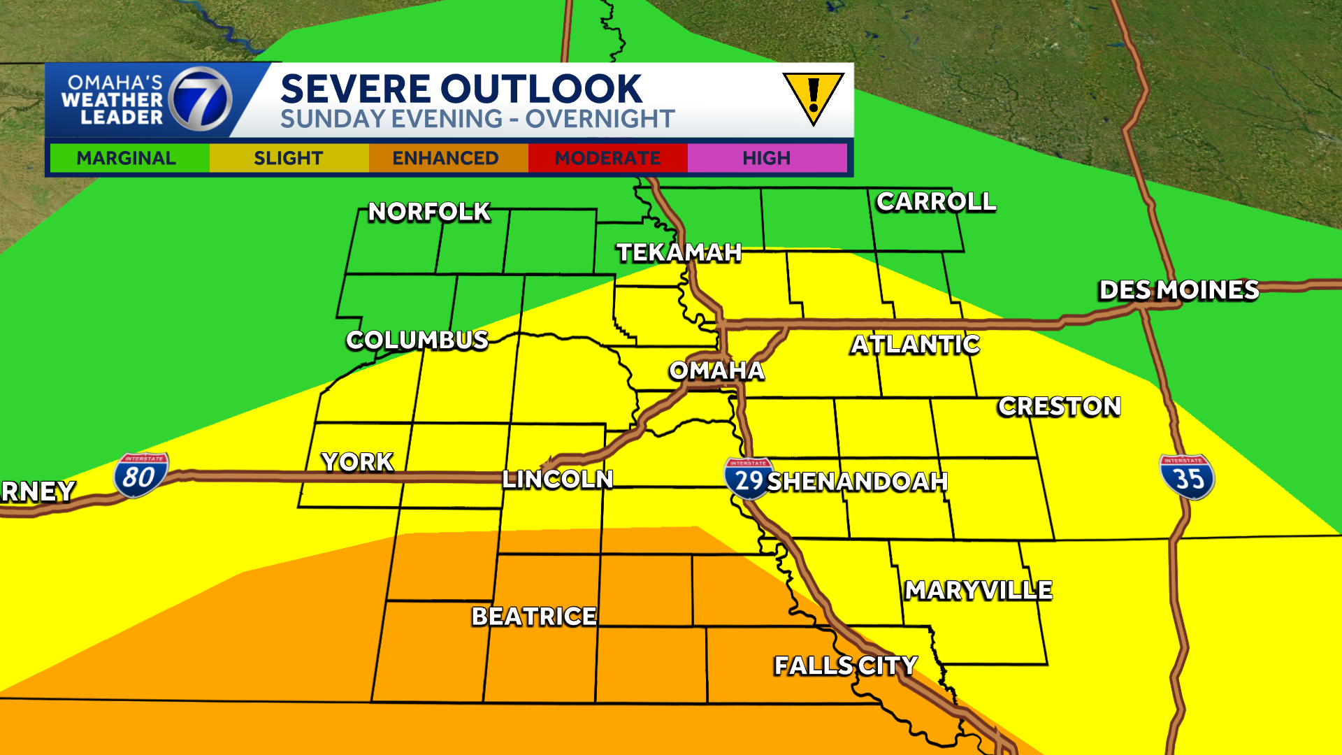
Chance for severe storms Sunday for Omaha area
SOME SMALL STORMS TO HELP CELEBRATE. I GUESS IF YOU LOOK AT IT THAT WAY. YEAH, YEAH WE DID. I MEAN, IT WAS KIND OF A NICE DAY. YOU COULD SIT INSIDE, YOU COULD READ A BOOK, YOU COULD LOOK OUTSIDE ON THIS WEEKEND AND, YOU KNOW, MAYBE ENJOY SEEING SOME OF THAT RAIN COME DOWN. WE’RE ALMOST DONE WITH THE RAIN NOW IN OMAHA. AT LEAST WE WILL BE VERY SHORTLY. IT SEEMS LIKE IT’S GOING TO PRESS INTO IOWA. AND REALLY, ANY RUMBLES OF THUNDER ARE NOW BECOMING VERY ISOLATED AS WE LOOK AT RADAR. SO I THINK DOWN TO THE WEST, IF YOU LOOK JUST WEST OF LANCASTER COUNTY, THERE NEAR CRETE, THERE ARE SOME STORMS BUBBLING UP THERE. I MEAN, VERY SMALL, BUT SOME OF THOSE COULD BE KIND OF SPOTTY AND AROUND THE AREA AS WE WORK OUR WAY INTO THE OVERNIGHT HOURS, LET’S TALK ABOUT STORMS FOR TOMORROW, BECAUSE THAT’S GOING TO BE KIND OF OUR MAIN EVENT WHEN IT COMES TO STORMS THROUGH THE WEEKEND. WE’RE IN A SLIGHT RISK FROM THE STORM PREDICTION CENTER. THAT WOULD BE THE YELLOW SHADE A LEVEL TWO, THE LEVEL THREE EXTENDS DOWN INTO FAR SOUTHEASTERN NEBRASKA, AND THE LEVEL ONE IS MUCH FURTHER NORTH ON MONDAY. THIS WILL ALL SHIFT WAY FAR TO THE EAST, AND WE REALLY WON’T BE IN MUCH OF A RISK AFTER THAT. LET’S WALK THROUGH THIS HERE ON STORM PREDICTOR STARTING AT THE TIME. RIGHT NOW, THERE’S OUR ISOLATED AND SCATTERED STORMS. FOR THE TIME BEING, ONCE WE GET TO 2 A.M., THIS IS PAST MIDNIGHT, MAYBE A COUPLE RUMBLES OF THUNDER AROUND WITH THESE SHOWERS FEW AND FAR BETWEEN. ONCE WE GET TO SUNDAY MORNING, THEY’RE PRETTY MUCH DONE AND IT’S CLOUDY SKIES OUTSIDE OF MAYBE COLUMBUS NORFOLK TEKAMAH AN AREA YOU COULD GET A SPOTTY SHOWER OR RUMBLE OF THUNDER. THERE’S THE LUNCH HOUR TOMORROW, STILL LIKELY DRY WITH THE CLOUDS HANGING AROUND, STORMS DEVELOPING AFTER 4:00, OR MOVING INTO THE AREA. I SHOULD SAY AROUND 4:00. THE BETTER INGREDIENTS WILL BE A LITTLE FURTHER SOUTH WHERE THERE’S MORE HUMIDITY. SO AREAS LIKE BEATRICE, NEMAHA, FALLS CITY, THOSE LOCATIONS COULD SEE A STRONGER THUNDERSTORM TOMORROW EVENING. THIS IS 10 P.M. THIS COULD BE ANOTHER SCATTERED ROUND OF SHOWERS AND THUNDERSTORMS THAT COMES THROUGH. THIS WILL INCREASE IN COVERAGE DURING THE OVERNIGHT HOURS. AND REALLY THE BEST INGREDIENTS FOR REALLY, REALLY STRONG STORMS WILL ACTUALLY BE IN KANSAS AROUND THIS TIME OVERNIGHT. PROBABLY NOT FOR OMAHA. ARE STRONGER. ROUND OF STORMS WILL PROBABLY COME AROUND THAT FOUR, FIVE, 6:00 TIME WINDOW ON SUNDAY AFTERNOON AND EVENING. AND HERE’S OUR LAST ROUND COMING MONDAY AROUND THE LUNCH HOUR. AND THERE WILL BE SOME RUMBLES OF THUNDER IN HERE, A LOWER SEVERE THREAT. ONCE THAT SHIFTS OFF, WE LOOK RAIN FREE FOR QUITE SOME TIME. WE’RE GOING TO PICK UP ON A LOT OF MOISTURE WITH THIS. IT SEEMS LIKE WITH MULTIPLE ROUNDS OF RAIN AND STORMS, SOME AREAS COULD GET AN INCH OR MAYBE EVEN TWO INCHES, DEPENDING ON IF YOU’RE LUCKY OR UNLUCKY, DEPENDING ON IF STORMS GO OVER YOU. THERE’S A LIVE LOOK OUTSIDE RIGHT NOW. RAINDROPS ON THE SKYCAM AGAIN. THE RAIN IS PRETTY MUCH DWINDLING DOWN TO AN END. NOW. 52 DEGREES IN NORTHEAST WIND AT TEN MILES PER HOUR. HERE’S YOUR LOW TEMPERATURES FOR TONIGHT. I MEAN, YOU’LL START SUNDAY AROUND 50 DEGREES. SO MAYBE A LITTLE BIT OF CHILL TO THE AIR OUTSIDE. IF YOU’RE HEADING TO A CHURCH SERVICE EARLY BY THE AFTERNOON, I THINK WE WARM UP TO ABOUT 70 DEGREES JUST BEFORE THE RAIN COMES IN. AND THAT RAIN COOLED AIR WILL BRING TEMPERATURES A LITTLE BIT COOLER BY THE TIME WE GET TO THE EVENING HOURS. SO SUNDAY AND MONDAY ARE IMPACT WEATHER DAYS AGAIN, MULTIPLE ROUNDS OF SHOWERS AND THUNDERSTORMS. I THINK IF WE NEED TO LOOK FOR THE MOST LIKELY TIME FOR A STRONG TO SEVERE THUNDERSTORM, IT’S FOR OMAHA PROBABLY GOING TO COME WITH THAT FIRST ROUND WHICH COMES IN MAYBE AROUND 4 OR 5, 6:00, AND THEN WE’LL WAIT FOR MORE SCATTERED ROUNDS OF SHOWERS AND THUNDERSTORMS THROUGH THE OVERNIGHT HOURS AND MAYBE EVEN ANOTHER ROUND COMING MIDDAY ON MONDAY BEFORE WE’RE DONE WITH THE RAIN. AND IF YOU WANT TO TRACK ALL THIS DOWN TO THE KETV MOBILE APP, IT GIVES YOU A LOOK AT OUR INTERACTIVE RADAR, AND IT WILL GIVE YOU STORM ALERTS IF SEVERE WEATHER IS NEAR
Advertisement
Rain and storm chances are back in the forecast for the final weekend of April. Omaha’s Weather Leader has deemed Sunday an impact weather day with chances for showers and strong to severe thunderstorms. Sunday storm threatThough Sunday will likely start off dry, but multiple rounds of showers and thunderstorms will be possible during the afternoon and overnight hours. The first round of storms could impact Omaha after 5 PM with isolated large hail up to 2 inches, damaging wind gusts up to 75 mph, isolated tornadoes, and heavy rain possible. The second round of storms will be possible after 10 PM with large hail, damaging wind gusts and isolated tornadoes as threats. The Storm Prediction Center has areas generally north of I-80 in a marginal risk for severe weather with a slight to enhanced risk for severe storms south of I-80. Stay updated on the latest weather forecast by downloading the KETV mobile app.With a combined 50 years covering weather in Nebraska and Iowa, KETV NewsWatch 7 is Omaha’s Weather Leader. Led by Omaha’s Chief Meteorologist Bill Randby, the award-winning team of Sean Everson, Caitlin Harvey and Luke Vickery are focused on alerting you to upcoming severe weather and KETV’s exclusive live radar gives you a 3-minute advantage when storms strike.Make sure you can always see the latest news, weather, sports and more from KETV NewsWatch 7 on Google search.NAVIGATE: Home | Weather | Local News | National | Sports | Newscasts on demand |
Rain and storm chances are back in the forecast for the final weekend of April. Omaha’s Weather Leader has deemed Sunday an impact weather day with chances for showers and strong to severe thunderstorms.
Sunday storm threat
Advertisement
Though Sunday will likely start off dry, but multiple rounds of showers and thunderstorms will be possible during the afternoon and overnight hours.
The first round of storms could impact Omaha after 5 PM with isolated large hail up to 2 inches, damaging wind gusts up to 75 mph, isolated tornadoes, and heavy rain possible.
The second round of storms will be possible after 10 PM with large hail, damaging wind gusts and isolated tornadoes as threats.
The Storm Prediction Center has areas generally north of I-80 in a marginal risk for severe weather with a slight to enhanced risk for severe storms south of I-80.

Stay updated on the latest weather forecast by downloading the KETV mobile app.
With a combined 50 years covering weather in Nebraska and Iowa, KETV NewsWatch 7 is Omaha’s Weather Leader. Led by Omaha’s Chief Meteorologist Bill Randby, the award-winning team of Sean Everson, Caitlin Harvey and Luke Vickery are focused on alerting you to upcoming severe weather and KETV’s exclusive live radar gives you a 3-minute advantage when storms strike.
Make sure you can always see the latest news, weather, sports and more from KETV NewsWatch 7 on Google search.
NAVIGATE: Home | Weather | Local News | National | Sports | Newscasts on demand |