
Read the full article on KETV 7
Lingering showers, storms possible Monday in Omaha area
METEOROLOGIST. CAITLIN HARVEY. WITH THE ACCURATE FORECAST, YOU CAN TRUST. 1215 NOW HERE ON YOUR MONDAY AFTERNOON, STARTING WITH A LIVE, DREARY GRAY LOOK OUT OVER OMAHA FROM OUR CAMERA 27TH AND DOUGLAS SHERIDAN WITH SOME OF THE RAIN SHOWERS, YOU MIGHT STILL ENCOUNTER A BIT OF MIST AND DRIZZLE, AND THESE CLOUDS LIKELY TO STICK AROUND HERE TODAY. OVERCAST SKIES OMAHA 56. LINCOLN 5849 NORFOLK IN THAT COLD FRONT THROUGH A BIT QUICKER. 71 STILL IN MARYVILLE AND THOSE WINDS RAMPING UP. SEEING OUR GUSTS NOW ABOUT 20 TO 30 MILES AN HOUR, 32 MILE AN HOUR GUSTS NOW RECORDED AT NORFOLK 28 HERE FOR OMAHA. WE’RE GOING TO KEEP THINGS A BIT ON THE WINDIER SIDE HERE TODAY. NOW LIVE SUPER DOPPLER WITH OUR THREE-MINUTE ADVANTAGE SHOWING JUST A COUPLE OF SHOWERS NOW MOVING THROUGH ON INTO PARTS OF FAR SOUTHEAST NEBRASKA. NORTH SOUTHWEST IOWA AND NORTHWEST MISSOURI. THOUGH PARTS OF SOUTHEAST NEBRASKA MIGHT GET A COUPLE MORE SHOWERS HERE BY YOUR AFTERNOON. SO KEEPING A CLOSE EYE ON NATIONAL WEATHER OUT TOWARD THE SAINT LOUIS AREA, WHERE THEY COULD SEE NUMEROUS TORNADOES AND GOLF BALL SIZED HAIL GUSTS UP TO ABOUT 70 TO 80 MILES AN HOUR POSSIBLE. WE’RE QUIETING THINGS DOWN HERE, AT LEAST FOR THE TIME BEING, FOR EASTERN NEBRASKA, WESTERN IOWA, NORTHWEST MISSOURI, TEMPERATURES ALREADY MADE IT PAST THE WARMEST PART OF THE DAY. GOING TO CONTINUE TO DROP INTO YOUR AFTERNOON BY 5:00, 53 DEGREES, STILL GUSTY. AND OVERNIGHT TONIGHT, STILL GUSTY THROUGH THE FIRST HALF OF THE EVENING, ESPECIALLY UP TO ABOUT 30 MILES AN HOUR TO THE NORTHWEST. LOWS DROPPING INTO THE UPPER 30S LOWER 40S. SO A BIT OF A CHILL IN THE AIR TO START YOUR DAY TOMORROW. NOW STORM PREDICTOR HERE FOR US THROUGHOUT THE REST OF THE DAY TODAY. WE DO HAVE THAT SLIGHT CHANCE FOR A COUPLE MORE SHOWERS, MAYBE A RUMBLE OF THUNDER INTO SOUTHEAST NEBRASKA. BUT NORTHWEST MISSOURI AND SOUTHWEST IOWA, ESPECIALLY INTO SOUTH CENTRAL IOWA. HIGHER CHANCE THERE FOR SOME OF THOSE SHOWERS AND STORMS OVERNIGHT TONIGHT. MOSTLY CLOUDY SKIES BECOMING PARTLY CLOUDY AND CHILLY TOMORROW MORNING. WATCHING THOSE CLOUDS RETURN FOR YOUR TUESDAY AND ESPECIALLY TOMORROW AFTERNOON. CHANCES FOR SPOTTY SHOWERS AND AN OUTSIDE CHANCE FOR A RUMBLE OF THUNDER. THOSE SEVERE OUTLOOK FOR THIS AFTERNOON CONTINUE TO SHIFT OVER TO THE EAST. OUTSIDE CHANCE FOR AN ISOLATED STORM. NORTHWEST MISSOURI AND CENTRAL IOWA. SEVEN-DAY FORECAST TODAY NO LONGER IMPACT WEATHER FOR THE REST OF THE DAY, THOUGH THOSE TEMPERATURES WILL CONTINUE TO DROP A LITTLE BIT INCONVENIENT 30% CHANCE FOR SPOTTY SHOWERS, POSSIBLY A RUMBLE OF THUNDER TOMORROW, THOUGH. NO SEVERE WEATHER HERE AND HEADING INTO THE REST OF THE WEEK. MID 60S. TH
Advertisement
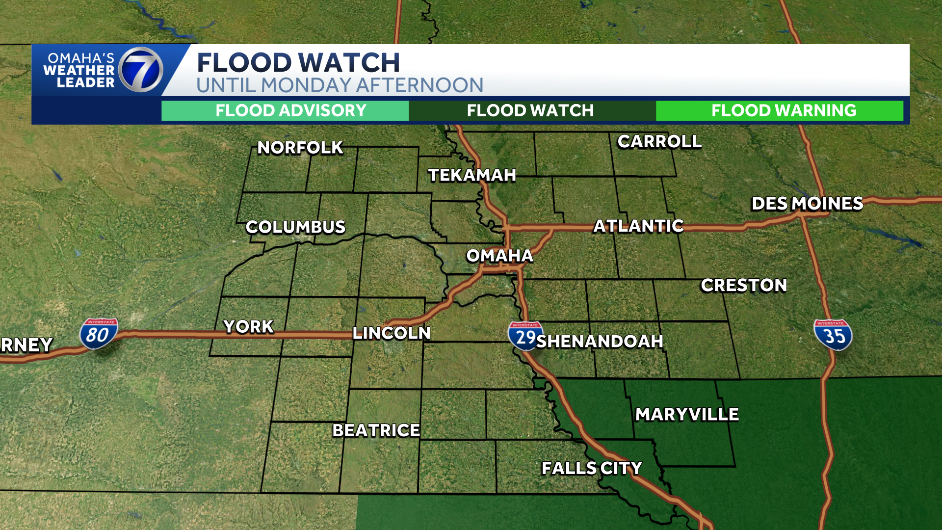
Omaha’s Weather Leader has deemed Monday an impact weather day with chances for showers and a few storms in the morning. Monday MorningThere is currently a flood watch for parts of northwest Missouri into Monday afternoon. This is where the heaviest rain will fall leading up to the morning rush hour.Roads will likely be wet in the Omaha metro, but rain will be coming to an end after the sun comes up.We will watch for another round of scattered showers and and possibly a few storms along a cold front before noon Monday. The storm prediction center has placed parts of western Iowa under a low risk of severe storms.Any rain on Monday will be done before noon in the metro. There is another chance for spotty showers Tuesday. Stay updated on the latest weather forecast by downloading the KETV mobile app.With a combined 50 years covering weather in Nebraska and Iowa, KETV NewsWatch 7 is Omaha’s Weather Leader. Led by Omaha’s Chief Meteorologist Bill Randby, the award-winning team of Sean Everson, Caitlin Harvey and Luke Vickery are focused on alerting you to upcoming severe weather and KETV’s exclusive live radar gives you a 3-minute advantage when storms strike.Make sure you can always see the latest news, weather, sports and more from KETV NewsWatch 7 on Google search.NAVIGATE: Home | Weather | Local News | National | Sports | Newscasts on demand |
Omaha’s Weather Leader has deemed Monday an impact weather day with chances for showers and a few storms in the morning.
Monday Morning
Advertisement
There is currently a flood watch for parts of northwest Missouri into Monday afternoon. This is where the heaviest rain will fall leading up to the morning rush hour.

Roads will likely be wet in the Omaha metro, but rain will be coming to an end after the sun comes up.
We will watch for another round of scattered showers and and possibly a few storms along a cold front before noon Monday. The storm prediction center has placed parts of western Iowa under a low risk of severe storms.

Any rain on Monday will be done before noon in the metro. There is another chance for spotty showers Tuesday.
Stay updated on the latest weather forecast by downloading the KETV mobile app.
With a combined 50 years covering weather in Nebraska and Iowa, KETV NewsWatch 7 is Omaha’s Weather Leader. Led by Omaha’s Chief Meteorologist Bill Randby, the award-winning team of Sean Everson, Caitlin Harvey and Luke Vickery are focused on alerting you to upcoming severe weather and KETV’s exclusive live radar gives you a 3-minute advantage when storms strike.
Make sure you can always see the latest news, weather, sports and more from KETV NewsWatch 7 on Google search.
NAVIGATE: Home | Weather | Local News | National | Sports | Newscasts on demand |