Read the full article on KETV 7
Omaha weather: Showers and storms over the weekend for Nebraska, Iowa
YEAH, I KNOW THE HUMIDITY KIND OF THE FIRST TIME WE FELT IT SO FAR THIS SEASON. OF COURSE THERE’S GOING TO BE MORE DAYS TO COME. SO THERE’S A LOT OF FOLKS GOING TO THE FARMER’S MARKETS HERE IN THE NEXT FEW MONTHS. AND ABSOLUTELY SWEATING A LOT, BECAUSE THAT’S HOW IT IS HERE IN THE MIDWEST. WITH THE HUMIDITY, THOUGH, COMES SEVERE WEATHER, AT LEAST SEVERE STORMS FROM TIME TO TIME. AND WE HAD SOME THREAT FOR SEVERE WEATHER TODAY. IT STAYED PRETTY MUCH SOUTH OF OMAHA IN AREAS LIKE FAR SOUTHEAST NEBRASKA, KIND OF NEAR BEATRICE, FALLS CITY AREA, AND THEN INTO NORTHWEST MISSOURI. NOW MOVING FORWARD, WE HAVE A PRETTY LOW, SEVERE THREAT THROUGH THE NEXT COUPLE OF DAYS. BUT THERE IS A SEVERE THREAT THROUGH ABOUT TUESDAY. THERE’S NO GUARANTEE OF SEVERE WEATHER, THOUGH. IT LOOKS LIKE WE’RE LACKING A TRIGGERING MECHANISM. YOU NEED SOME KIND OF SURFACE BOUNDARY TO MOVE THROUGH A COLD FRONT, A WARM FRONT, A DRY LINE, AN OUTFLOW BOUNDARY, ANYTHING LIKE THAT TO GET STORMS TO LIFT AND RISE. AND THAT STARTS THE PROCESS. IT LOOKS LIKE THAT’S GOING TO BE FAIRLY LIMITED. ALL THE INGREDIENTS WILL BE THERE FOR A STORM TO BECOME STRONG. IF IT DOES FORM. AND THEN WE’RE GOING TO STAY WARM. WE’RE GOING TO STAY WINDY AT LEAST FOR TODAY AND TOMORROW. WHEN IT COMES TO THE WIND SKYCAM, LOOK OUTSIDE. THAT’S DOUGLAS TOWER AT 63 DEGREES, THE SOUTHEAST BREEZE STILL BLOWING AT 13MPH AT 67 IN PLATTSMOUTH MID UPPER, MID AND LOWER 60S FOR CENTRAL WESTERN IOWA, 67 BEATRICE AND 68 DEGREES IN COLUMBUS. HERE’S LVIV DEUEL POLE WAS A LITTLE MORE ACTIVE A FEW HOURS AGO. WE HAD STORMS MOVE THROUGH JEFFERSON GAGE COUNTY, FAR SOUTHEAST NEBRASKA, AND NOW THIS IS KIND OF THE LAST OF IT. MOVING PAST MARYVILLE AND INTO OUR FAR EASTERN COUNTIES INTO FAR SOUTHWEST IOWA. AND THE SHOWERS NOW, AND IF YOU LOOK EVEN FURTHER DOWNSTREAM, YOU CAN SEE KIND OF MAYBE A SHOWER. RUMBLES OF THUNDER NEAR KANSAS CITY TRYING TO LIFT NORTHWARD. AND OUR COMPUTER MODEL INSISTS THAT MAYBE A SHOWER OR THUNDERSTORM WILL ROLL THROUGH SOUTH OF OMAHA DURING THE OVERNIGHT HOURS. I’M JUST NOT SEEING A LOT IN CENTRAL KANSAS THAT WILL HOLD ON THROUGH THE OVERNIGHT HOURS. SO I THINK THAT’S PROBABLY WE’LL STAY A 30% CHANCE. NOW AS WE GET INTO THE DAY ON SUNDAY, THERE’S GOING TO BE STORMS LIKELY TOWARDS KANSAS CITY OR THE EXTREME SOUTHEAST SIDE OF OUR VIEWING AREA. BUT I THINK THAT’S IT. AND WE’LL EVENTUALLY SEE MORE SUNSHINE LATER IN THE DAY. AND WE LOOK FOR A TRIGGERING MECHANISM, MAYBE CLOSER TO THIS AREA OF LOW PRESSURE MONDAY MORNING FOR A THUNDERSTORM THAT REALLY COULD BE ANYWHERE. IT SHOWED IT MOVING NORTH OF OMAHA, BUT IT’S CERTAINLY POSSIBLE IT COULD MOVE THROUGH OMAHA TOO. IT’S JUST TOUGH TO TELL WHERE THAT TRIGGERING MECHANISM IS GOING TO TAKE PLACE. AND HERE’S MONDAY AT 3:00 WHERE THERE’S A STATIONARY BOUNDARY LIKELY TO OUR NORTH, AND THAT COULD BE THE FOCAL POINT NEAR AN AREA OF LOW PRESSURE UP WAY NORTHEAST OF US, THE TWIN CITIES FOR SHOWERS AND THUNDERSTORMS. SO IT COULD BE US GETTING SHUT OUT FROM ANY RAIN THESE NEXT COUPLE DAYS. WE’LL JUST HAVE TO SEE WHERE STORMS FORM. THERE’S A MARGINAL RISK FROM THE STORM PREDICTION CENTER FOR TOMORROW, AND ANOTHER MARGINAL RISK, BUT MORE FAVORABLE INGREDIENTS NORTH AND EAST OF OMAHA FOR MONDAY NIGHT. HERE’S THE SEVEN DAY FORECAST HERE. SUNDAY AND MONDAY WE GET WARMER AGAIN. A LITTLE CHANCE OF A STORM ON SUNDAY. IT’S TOUGH TO TELL WHERE THAT COULD BE. IT COULD BE WELL NORTH OF THE VIEWING AREA, LIKE THAT COMPUTER MODEL DEPICTED ON MONDAY. IT’S MORE OF A NIGHTTIME THREAT, BUT IT LOOKS LIKE THAT THREAT IS MORE NORTH OF OMAHA AS WELL. TUESDAY WILL WATCH FOR ANOTHER DAY OF MAYBE A SCATTERED SHOWER OR THUNDERSTORM WEDNESDAY AND THURSDAY. WE STAY WARM OUTSIDE. THURSDAY WILL ACTUALLY WATCH ANOTHER COLD FRONT COME THROUGH. EXCUSE ME, THAT’S ACTUALLY FRIDAY AND WE’LL HAVE TO SEE IF THAT SPARKS ANY SHOWERS OR STORMS AS WELL. SO KIND OF AN ACTIVE PATTERN HERE, BUT IT’S A LOT WARMER. AND LIKE WE’RE MENTIONING IT’S GOING TO BE MORE HUMID TO SAY UPPER 80S. BEEN A WHILE SINCE WE’RE GOING TO FEEL THAT CONSISTENTLY. I KNOW THE LAST TIME WE HAD IT,
Advertisement
Omaha weather: Showers and storms over the weekend for Nebraska, Iowa

Omaha’s Weather Leader has labeled multiple days as impact weather day this week. We look ahead to a more active stretch with multiple chances for rain and storms. A tornado warning was issued for parts of Jefferson and Gage counties in Nebraska, but it has since been suspended.Weekend storm chancesScattered rain and storms are possible through the morning with the arrival of a warm front. Any thunderstorms that redevelop late Saturday morning into the afternoon will have a risk of becoming severe with large hail and damaging wind gusts. Thunderstorms are possible again Sunday afternoon with a severe risk for large hail and damaging wind gusts.The Storm Prediction Center has placed a marginal risk for isolated severe storms across parts of eastern Nebraska and western Iowa, including the Omaha and Lincoln metro areas, for both Saturday and Sunday.Early week thunderstorms We’re watching Monday and Tuesday for the potential of multiple rounds severe weather as an unstable air mass from the Gulf arrives. The Storm Prediction Center has highlighted parts of far eastern Nebraska and western Iowa, including the Omaha metro, under a low risk of severe weather. Though details on timing still need to be ironed out, we will be monitoring the threat for large hail, damaging wind gusts, and tornadoes closely as Monday and Tuesday approach.Stay updated on the latest weather forecast by downloading the KETV mobile app.With a combined 50 years covering weather in Nebraska and Iowa, KETV NewsWatch 7 is Omaha’s Weather Leader. Led by Omaha’s Chief Meteorologist Bill Randby, the award-winning team of Sean Everson, Caitlin Harvey and Luke Vickery are focused on alerting you to upcoming severe weather and KETV’s exclusive live radar gives you a 3-minute advantage when storms strike.Make sure you can always see the latest news, weather, sports and more from KETV NewsWatch 7 on Google search.NAVIGATE: Home | Weather | Local News | National | Sports | Newscasts on demand |
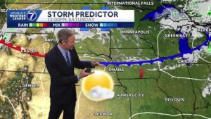
Omaha’s Weather Leader has labeled multiple days as impact weather day this week. We look ahead to a more active stretch with multiple chances for rain and storms.
A tornado warning was issued for parts of Jefferson and Gage counties in Nebraska, but it has since been suspended.
Advertisement
Weekend storm chances
Scattered rain and storms are possible through the morning with the arrival of a warm front. Any thunderstorms that redevelop late Saturday morning into the afternoon will have a risk of becoming severe with large hail and damaging wind gusts.
Thunderstorms are possible again Sunday afternoon with a severe risk for large hail and damaging wind gusts.
The Storm Prediction Center has placed a marginal risk for isolated severe storms across parts of eastern Nebraska and western Iowa, including the Omaha and Lincoln metro areas, for both Saturday and Sunday.


Early week thunderstorms
We’re watching Monday and Tuesday for the potential of multiple rounds severe weather as an unstable air mass from the Gulf arrives. The Storm Prediction Center has highlighted parts of far eastern Nebraska and western Iowa, including the Omaha metro, under a low risk of severe weather. Though details on timing still need to be ironed out, we will be monitoring the threat for large hail, damaging wind gusts, and tornadoes closely as Monday and Tuesday approach.


Stay updated on the latest weather forecast by downloading the KETV mobile app.
With a combined 50 years covering weather in Nebraska and Iowa, KETV NewsWatch 7 is Omaha’s Weather Leader. Led by Omaha’s Chief Meteorologist Bill Randby, the award-winning team of Sean Everson, Caitlin Harvey and Luke Vickery are focused on alerting you to upcoming severe weather and KETV’s exclusive live radar gives you a 3-minute advantage when storms strike.
Make sure you can always see the latest news, weather, sports and more from KETV NewsWatch 7 on Google search.
NAVIGATE: Home | Weather | Local News | National | Sports | Newscasts on demand |