
Read the full article on KETV 7
Chance for strong storms Saturday and Sunday for Omaha area
CHRISTIANE CORDERO, ABC NEWS, WASHINGTON. NOW FROM OMAHA’S WEATHER LEADER, METEOROLOGIST CAITLIN HARVEY. WITH THE ACCURATE FORECAST, YOU CAN TRUST. 14 HERE ON YOUR FRIDAY. TAKING ANOTHER BEAUTIFUL LOOK AT OUR CLEAR SKIES OUT THERE. ALL OF OUR GRASS TREES TURNING GREEN. IT’S NOT GREAT NEWS FOR SOME OF US SUFFERING FROM ALLERGIES, BUT A BEAUTIFUL DAY NONE THE LESS. TEMPERATURES IN THE MID TO UPPER 50S HERE AT THE LUNCH HOUR, WITH WINDS ABOUT 5 TO 15 MILES AN HOUR OUT OF THE NORTH. SEEING THOSE GUSTS APPROACHING 2025 MILES AN HOUR, JUST A LITTLE TAD ON THE BREEZY SIDE HERE TODAY, BUT REALLY NOTHING THAT’S GOING TO IMPACT YOUR BEAUTIFUL AFTERNOON HERE IN DEUEL. SUPER DOPPLER WITH OUR THREE-MINUTE ADVANTAGE STILL SHOWING CRYSTAL CLEAR CONDITIONS, EASTERN NEBRASKA, WESTERN IOWA, NORTHWEST MISSOURI AND EXPECTED TO KEEP IT THAT WAY THROUGHOUT THE AFTERNOON, THOUGH, THOSE CLOUDS GOING TO INCREASE TONIGHT HERE LATER IN THE DAY, TEMPERATURES INTO THE UPPER 60S FEW OF US INTO THE LOWER 70S SOUTH OF I-80 ON THE NEBRASKA SIDE. 32 TODAY, BEATRICE 68 THIS AFTERNOON. OMAHA SHENANDOAH, COLUMBUS GETTING UP TO 66 CARROLL STILL PRETTY SEASONALLY COMFORTABLE HERE FOR TONIGHT. COOL. 45, BUT RIGHT ON PAR WITH WHERE OUR TEMPERATURES SHOULD BE. WE’LL GET THOSE INCREASING CLOUDS, MOSTLY CLEAR SKIES BECOMING PARTLY TO MOSTLY CLOUDY BY OR SATURDAY MORNING. BUT LET’S BREAK DOWN WHAT TO EXPECT HERE FOR YOUR FRIDAY AND ON INTO THE WEEKEND. AGAIN, CRYSTAL CLEAR THAT DRIVE HOME THOUGH. STILL GOING TO BE PRETTY BRIGHT. COULD STILL SEE WIND GUSTS UP TO ABOUT 1520 MILES AN HOUR OVERNIGHT TONIGHT. 10 P.M. FRIDAY NIGHT. PLANS STILL LOOKING GOOD, BUT INCREASING CLOUDS OVERNIGHT. WAKING UP TOMORROW MORNING, ESPECIALLY ON THE NEBRASKA SIDE WEST OF THE OMAHA METRO. STARTING OFF MOSTLY CLOUDY. CHANCE FOR SOME VERY SPOTTY SHOWERS. MAYBE A RUMBLE OF THUNDER OR TWO AND DOES NOT LOOK LIKE A TOTAL WASHOUT. COULD YOU STILL GET YARD WORK DONE IN THE MORNING? ABSOLUTELY. BUT THE AFTERNOON, SEEING THOSE SPOTTY SHOWERS AND STORMS NOW OVERNIGHT SATURDAY INTO EARLY SUNDAY, WE’LL KEEP THOSE CLOUDS WITH US. FOR FOLKS IN NEBRASKA BY THE AFTERNOON. INCREASING CHANCES FOR SHOWERS AND STORMS, ESPECIALLY AFTER ABOUT 2 TO 3 P.M. TOMORROW. THOSE CONTINUE TO WORK THEIR WAY TOWARD THE NORTHEAST. AS WE HEAD INTO YOUR SUNDAY EVENING AND OVERNIGHT SUNDAY INTO EARLY MONDAY, ANOTHER OPPORTUNITY FOR SOME OF THOSE STRONG TO SEVERE STORMS. YOUR SEVERE WEATHER OUTLOOK SUNDAY EVENING, SUNDAY NIGHT, EVEN INTO THE EARLY HOURS OF MONDAY, AS MUCH OF EASTERN NEBRASKA, WESTERN IOWA REALLY, INCLUDING THE OMAHA AND LINCOLN AREAS AND THAT SLIGHT RISK FOR LARGE HAIL, DAMAGING WINDS AND. WE CANNOT RULE OUT AN ISOLATED TORNADO RIGHT NOW. SEEING AN IMPACT WEATHER THROUGH YOUR WEEKEND. AGAIN, NOT A TOTAL WASHOUT, BUT SPOTTY SHOWERS FOR YOUR SATURDAY, SUNDAY AFTERNOON, EVENING NIGHT COULD GET A BIT HAIRY AND WAKING UP EARLY MONDAY MORNING. 70% CHANCE FOR THOSE SHOWERS AND THUNDERSTORMS TO BEAT. YEAH, TODAY IS DEFINITELY THAT TIME FOR THAT PATIO WEATHER. AND WITH THE BURN BAND GOING, MAYBE EVEN A TIME TO GRILL. GOOD GRILLING WEATHER TONIGHT. DEFINITELY, DE
Advertisement
Chance for strong storms Saturday and Sunday for Omaha area

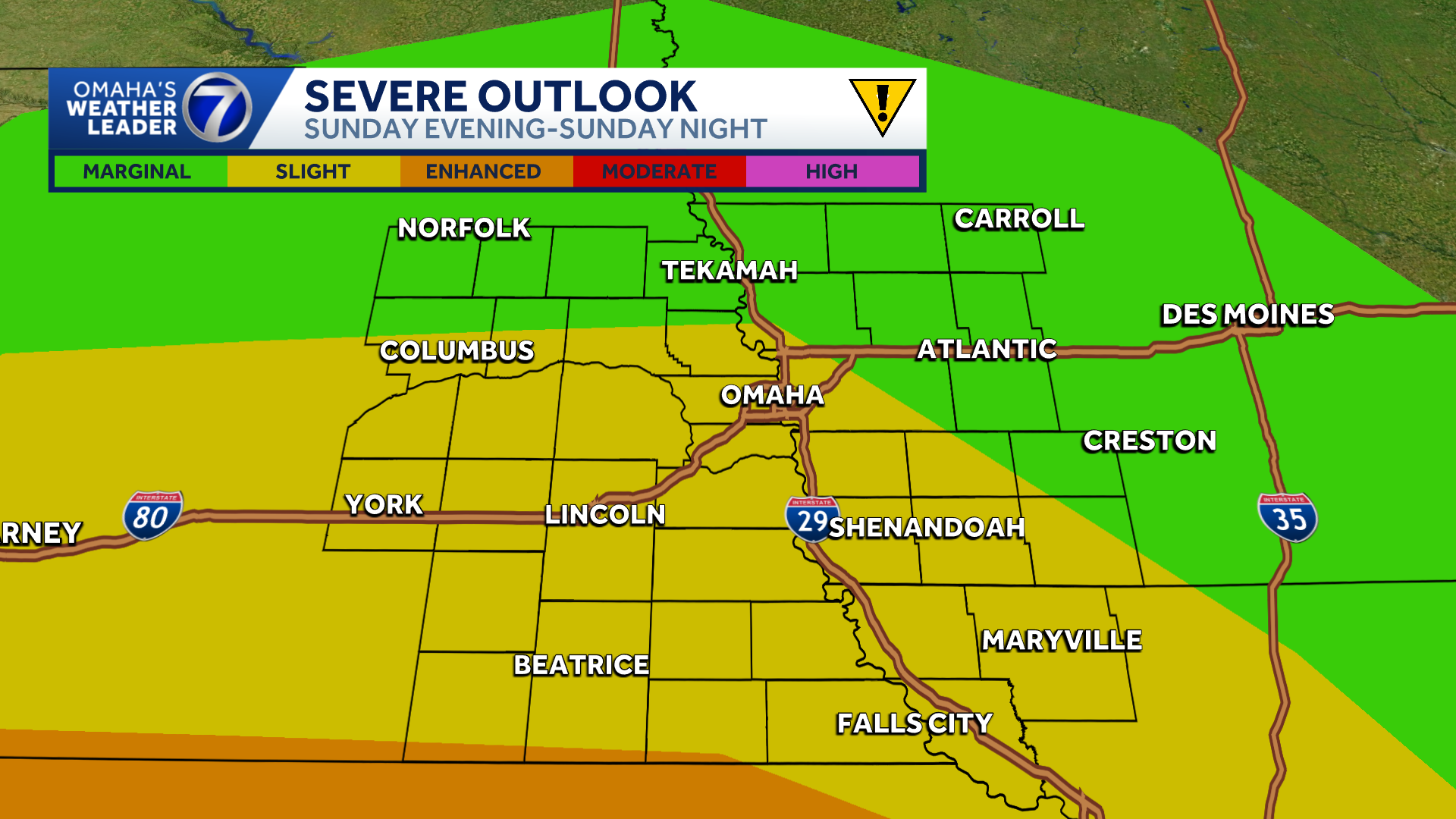
Rain and storm chances are back in the forecast for the final weekend of April. Omaha’s Weather Leader has deemed Saturday and Sunday as impact weather days with chances for showers and strong to severe thunderstorms.Saturday showers and stormsAs of Friday afternoon, scattered showers are possible Saturday morning with thunderstorms possible during the afternoon hours. The Storm Prediction Center has placed a marginal risk for isolated severe thunderstorms over parts of southeastern Nebraska, including the Lincoln area. Large hail and damaging winds will be possible. Sunday storm threatThough Sunday will likely start off dry, showers and thunderstorms could develop after 2 PM as a warm front lifts through the area. Strong to severe storms will be possible during the late afternoon Sunday into the overnight hours.The Storm Prediction Center has areas around and south of Omaha in a slight risk for severe storms Sunday evening into Sunday night. Areas near and south of the Kansas border are in an enhanced risk area. Large hail and damaging winds are the primary threats with any severe weather that develops, but isolated tornadoes cannot be ruled out. Stay updated on the latest weather forecast by downloading the KETV mobile app.With a combined 50 years covering weather in Nebraska and Iowa, KETV NewsWatch 7 is Omaha’s Weather Leader. Led by Omaha’s Chief Meteorologist Bill Randby, the award-winning team of Sean Everson, Caitlin Harvey and Luke Vickery are focused on alerting you to upcoming severe weather and KETV’s exclusive live radar gives you a 3-minute advantage when storms strike.Make sure you can always see the latest news, weather, sports and more from KETV NewsWatch 7 on Google search.NAVIGATE: Home | Weather | Local News | National | Sports | Newscasts on demand |
Rain and storm chances are back in the forecast for the final weekend of April. Omaha’s Weather Leader has deemed Saturday and Sunday as impact weather days with chances for showers and strong to severe thunderstorms.
Saturday showers and storms
Advertisement
As of Friday afternoon, scattered showers are possible Saturday morning with thunderstorms possible during the afternoon hours.
The Storm Prediction Center has placed a marginal risk for isolated severe thunderstorms over parts of southeastern Nebraska, including the Lincoln area. Large hail and damaging winds will be possible.

Sunday storm threat
Though Sunday will likely start off dry, showers and thunderstorms could develop after 2 PM as a warm front lifts through the area. Strong to severe storms will be possible during the late afternoon Sunday into the overnight hours.
The Storm Prediction Center has areas around and south of Omaha in a slight risk for severe storms Sunday evening into Sunday night. Areas near and south of the Kansas border are in an enhanced risk area. Large hail and damaging winds are the primary threats with any severe weather that develops, but isolated tornadoes cannot be ruled out.

Stay updated on the latest weather forecast by downloading the KETV mobile app.
With a combined 50 years covering weather in Nebraska and Iowa, KETV NewsWatch 7 is Omaha’s Weather Leader. Led by Omaha’s Chief Meteorologist Bill Randby, the award-winning team of Sean Everson, Caitlin Harvey and Luke Vickery are focused on alerting you to upcoming severe weather and KETV’s exclusive live radar gives you a 3-minute advantage when storms strike.
Make sure you can always see the latest news, weather, sports and more from KETV NewsWatch 7 on Google search.
NAVIGATE: Home | Weather | Local News | National | Sports | Newscasts on demand |